Tuesday, September 4, 2012

Fan House Graves

Like most people, I was born at a very young age. My formative years were spent in NEPA – North Eastern PA – Pennsylvania, that is. Coal was black gold and there were no movie stars. Well, except for that time Sean Connery came to Wilkes-Barre for the premier of his movie, “The Molly Maquires,” which was filmed in Eckley, PA. (Eckley is more or less a shanty town in Weatherly, about ten miles south of Wilkes-Barre.)

So coal was a way of life around these parts from the 1760s to the 1960s; my father, grandfather, and great-grandfather all worked in the mines in NEPA. When I was growing up in this area, abandoned coal breakers were commonplace (the breaker was the main structure in a “colliery,” which consisted of a mine and its complex of surface buildings). As a kid, my friends and I played near a hulking, crumbling concrete bunker that everyone called “the fan house.” I had no idea why it was called that, never even wondered. But now, forty years later, I found out why. 

Headstone, Wilkes-Barre City Cemetery  (P. Kinsman)
Some weeks ago, I drove through Wilkes-Barre City Cemetery on a rainy summer morning on my way to visit my mom. A photographer friend of mine, Patricia Kinsman, had posted a fabulous gravestone photo on Flickr about a year ago (see image directly above) - a photo that that she made in this cemetery - so I wanted to visit the place. (Click here to see her entire Flickr photostream). I was intrigued by the low angle she used, which sort of makes the stone look miniature.) 

Patricia described the cemetery as overgrown on a hillside sloping down toward the river. The City Cemetery sits next to the much fancier (and better cared for) Hollenback Cemetery, both of which are on River Street, across from the Wilkes-Barre General Hospital. Easy to find. Supposedly, people used to be buried in the Wilkes-Barre City Cemetery until their families had enough money to give them a proper burial at Hollenback Cemetery! (ref.)

Headstones with ruins of old building
As I drove the narrow road toward the back of the cemetery, it was obvious that some major brush-clearing had recently occurred. Trees had been cut and weeds had been whacked. The rain-rutted dirt road sloped treacherously down toward the river and looped back up the hill. I thought twice about driving my car down there, but the objection was sustained. Shadowing over this small section of the cemetery was the hulk of a large abandoned brick and concrete building. It was barely visible through the trees and you could see graffiti on the caved-in walls. The structure was not visible from the city street above. I took a few photos of the small stones around the building’s foundation and called it a day.

On my return to Philadelphia, I asked Patricia if she knew what the building was.  “A fan house,” was her reply, “...a ventilation system for a coal mine. There are giant fans that pulled air out of the coal mine.  The mine is still there, but sealed off.” 

Toppled monument in Wilkes-Barre City Cemetery
So THAT’S what a fan house is! (The fans of which she speaks were actually thirty-five FEET in diameter, and at the time, the largest in the United States.) My mission was clear. On my next visit, I needed to explore the fan house. (I did this a couple months later, getting much more than I bargained for. Stay tuned and read about this hair-raising experience next week!)

Fan inside Dorrance fan house (c. 1980s) (ref)
Schematic diagram of "Baltimore-style" fan house fan (ref)
Patricia’s Dad originally showed her the fan house, knowing that she liked to photograph abandoned buildings. He found these drawings and photos of the original buildings on line. The idea is fascinating, the technology a mechanical marvel at the time. 

c.1980s photo of Hillman fan house, Wilkes-Barre, PA  (ref)
The mining complex, of which the fan house (properly named the “Hillman" Fan House) was part, was known as the Dorrance Colliery. A "colliery," again, was the name given to the mine and all its outbuildings, including the main building, the coal breaker. The breaker was located about a quarter-mile up the (Susquehanna) river.   

Dorrance Colliery coal breaker, Wilkes-Barre, PA, c. 1980 (ref)
Here’s an image of the Dorrance Colliery’s massive coal breaker. The mine itself consisted of ten tunnels, most of which actually went under the river! Needless to say, the mine shafts tunneled under the City Cemetery as well. The Dorrance mining operation ceased in 1935 when the Susquehanna river broke through one of the tunnels.

Dorrance was owned and operated by the Lehigh Valley Railroad. Think about that. It was a tribute to railroad pioneer Asa Packer’s business acumen as owner of the Lehigh Valley Railroad to MINE his own fuel! And then haul it to regions in need of it! The colliery was in operation  from 1880 through 1959 (the year after I was born). Eventually abandoned, the structure was imploded in 1984. Today, the only remaining trace of the 550-acre Dorrance coal kingdom is the crumbling fan house, and the graves that lie in its ominous shadow. 

I find it interesting that the sign at the cemetery entrance indicates that it was established in 1871, and the fan house was (along with the rest of the colliery) was built around 1880. It appears that the Dorrance shafts tunneled under the cemetery which was already in existence. Convenient location, given all the mining-related deaths that occurred during the period the mine was in existence. 

As I mentioned earlier, I did return to explore the fan house, which you can read about next week. All I can say is that I failed to adequately prepare myself. I broke my own rules related to exploring abandoned buildings: 1) Never go alone; but if you must, 2) arm yourself.

1980s photo of fan house with headstone in foreground (ref)


References and Further Viewing:

Patricia Kinsman’s Flickr Photostream
Read about Sean Connery and the movie, The Molly Maquires 
Read about the actual Molly Maquires
Historic American Engineering Record, National Park Service, US Department of the Interior


Thursday, August 30, 2012

Jersey Shore Cemetery


What’s a summer beach vacation without a stop at a cemetery? Even when I take my family to the Jersey shore, I map out a local cemetery to visit. Now, Long Beach Island (South Jersey) has no graveyards to my knowledge, so you must head inland a bit. The town of Manahawkin on Route 9 in Ocean County is right on the mainland just before you hit the causeway out to the island. There are half a dozen small old graveyards between Manahawkin and Tuckerton, five miles south on Route 9. I figured that on Saturday morning, I’d get up before my wife and daughter, drive over and do some shooting.

So on Friday night, I told Jill I’d be heading out early the next morning to do some photography. She said she noticed that I was all shpilkas (Yiddish term for having ants in one’s pants) and looked like I needed to get it out of my system. I got my camera gear ready and set my alarm for six a.m. It feels most insane to wake up that early when you’re on vacation. 

Sunrise over the Atlantic Ocean, Beach Haven, New Jersey

When I awoke, I was surprised to see that the sun hadn’t yet risen! Can’t really make photographs without light, now can we? So I decided to go out to the beach and shoot the sunrise while I was waiting. (Here's a secret: I’ve made far more sunset photographs than sunrise ones.) It was quite a magnificent display that the summer sun presented about ten minutes later, here over the Atlantic Ocean. Took a few shots, sighed with awe at nature's majesty, then jumped into the car. There were tasks at hand. I only had two hours and still had to score coffee and a bun somewhere, creep the eight miles up the island at 25 mph, and tear across the causeway and Barnegat Bay at high speed.

Long Beach Island (LBI) really hasn’t changed much in the twenty-five years since I brought my first brood of children here. Quaint little shops and a family-oriented atmosphere, very few amusements and no boardwalk − totally unlike Wildwood and Atlantic City to its south. In fact, LBI seems to be the cutoff point between the north Jersey shore (with Asbury Park and Point Pleasant) and the south Jersey shore. Architecture changes drastically, vacationers are different. It’s much quieter and cleaner to the north. You begin to notice the change fairly quickly as you head north on Route 9 past Manahawkin.

Odd Fellows "FLT" symbol
Lighthouse engraving
As I hit town, I realized that over the years, I had passed Manahawkin’s Greenwood Cemetery so many times that my memories are worn (as John Prine says in his song Paradise). However, I never stopped there. Always had a carload of kids, or something. Times change. 


The front name fencing of this rural cemetery was bathed in the early rays from the sunrise − quite nice edge-of-the-day light with which to make photographs.  I like those sign fences, or whatever they’re called. I parked my wife’s Toyota RAV4 in the center of the small, football field-sized cemetery, got out and quickly surveyed the place. Only had an hour until I needed to head back to Beach Haven (I swear, that’s really the name of the town where we were staying), pick up Jill and Olivia (our three-year-old daughter), and head out to breakfast. Until then, I’d enjoy the quiet solitude of this Victorian seashore graveyard.
Plot borders at Greenwood Cemetery
The ground throughout the cemetery was sandy, with sparse grass. There were trees and old iron fencing at the front, the land grassier toward the back. There were strange, yet carefully delineated family plots throughout – all well-maintained. The borders were generally just low marble or concrete curbing with white gravel or sand over the graves. I couldn’t really do these justice with a photograph, so click my friend Kimberly Killeri’s video for a better idea of what I’m talking about (the video is interesting in its attention to detail). Greenwood offers just one angel statue at the back, but this lovely graveyard has many other things to offer gravers and taphophiles.

As I munched my glazed donut and set my convenience store coffee cup down on a tombstone, I noticed the odd little zinc medallion you see at left. I shot it and did a bit of research later. Remember the Boston Tea Party (1773)? Well, the "S and D of L" were responsible for that. The name "Sons and Daughters of Liberty" was given to the secret clubs of marauding American patriots that threatened the British ruling authority prior to 1776. Up and down the eastern seaboard, this "private band of societies provided an intercolonial network that would help forge unity" through "extralegal means" (reference: http://www.ushistory.org/us/10b.asp).

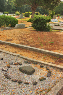
Another interesting thing I stumbled on (literally) was this set of stones at the front of Greenwood Cemetery. "Friend?" How close a "friend" would you say? This was not the family name, by the way. There was a large monument among these stones with that name one it.

Roaming around, I found several interesting decorative items, offerings, lighthouse carvings on stones, and so on. But, you know how every once in a while you find some REALLY unusual piece of architecture or statue that just produces utter delight? This was the case for me when I found this amazing little cast iron gate! It was swung partly open, and may have been like that for years – or at least since the last coastal storm. It bore the family name and date, along with a splendid harp design below. I don't believe I've ever seen one like it in person, though I'd seen vintage photos of them from cemeteries of the late 1800s.

All too soon, I'm tearing back over the causeway, the morning sun blazing as I drive past the weird Jersey signs, the custard stands, fudge shacks, the “Pottery  Barge.” I'm blasting Izzy Stradlin's G'n'R version of the Stones' Dead Flowers on the car stereo, feeling good about another successful adventure in a new cemetery. But I face another challenge: fighting the breakfast crowd at Uncle Will’s Pancake House.