Kind of a miserable afternoon here in Philadelphia. Raining like all get out. Sitting in the living room thinking that taking half a day off from work is the only right decision I’ve made in years. Certainly, the decision last weekend to find a certain old abandoned cemetery was not one of my best. In retrospect, I should have done a bit more research, but the thrill of the hunt was upon me. What I won't go through to find an abandoned cemetery...
Upfront, I thank Kim Thompson for the information on the lost cemetery of Pennypack Nature Preserve, and the detailed map she drew for me. (You
did say there was probably an easier way to access the cemetery, but I didn’t bother to check into that – my bad.) So, armed with a hand-drawn map, my friend Frank, water, beer, and snack bars, we set out to find this strange place in 95-degree weather. Her description of it being lost in the woods screamed “abandoned!” to me, and as you may know from reading my blog, I have more than a passing interest in abandoned cemeteries. Also, being an artist, I'm not as detail-oriented as I should be.

However, I did look up the Pennypack area and found that the Pennypack Ecological Restoration Trust (the location in question), was not to be confused with Pennypack Park in northeast Philly (although Pennypack Creek runs through both). I’d heard of the park over the years I’ve lived in Philly, but had never been there. Philadelphia is an enormous area, twenty miles across, with just so much nature, city, and everything in between (like water ice, which I’d have given anything for during this hike), that after twenty years, I still haven't taken it all in.
 |
| Tracks to Nowhere |
Kim and her husband had come upon the cemetery (in retrospect, I’m not sure how you come upon something hidden on a cliff above you and totally out of sight) during a hike through the Pennypack nature preserve, here in northeast Philadelphia. Actually, they went off the grid when they found a set of abandoned railroad tracks leading off into the woods (points for them - I'm not even sure that
I would have done
that). According to her map, I should follow the tracks about half a mile and I should see a couple houses up on a hill to the right, and the cemetery would be opposite them, on a hill to the left.
 |
| Pennypack Creek |
I parked my car at the Pennypack Road entrance (as the map indicated, near the intersection of Davisville and Terwood Roads) and Frank and I loaded up for the hike. It really was a beautiful area, with Pennypack Creek running alongside the main trail. About a quarter mile into the woods, Frank nonchalantly mentioned that he hoped we didn’t come across any rabid beavers. Say what? At the beginning of the month (June), three people had been bitten in and around Pennypack Creek. “
You mean that happened HERE?” I yelped. I made a mental note not to get too close to the water.
I hadn’t paid much attention to this seminal beaver event at the time, but now that I read up on it, I find it highly amusing, though for the folks involved, I’m sure it was not unlike the opening scene in the movie
JAWS. According to an NBC news article, ‘
Rabid Beavers Bite Folks in NE Philly,’ "
[The beaver] kind of went underwater and came up." Czech said "The wife started screaming and the husband looked over and saw the beaver biting on her leg." The article goes on to say this happened in Pennypack Creek near 'Ax Factory Road,' which I think you’ll admit is the best street name
ever!

The whole thing seems kind of stupid if you have no concept of how big beavers get. I for one, was shocked some years ago when I came across this stuffed beaver in a Baltimore thrift shop. The thing was huge, maybe four feet long including the tail! Throughout the day, Frank and I saw deer, snakes, and chipmunks, but met with no beavers (or bears, for that matter, as did the unfortunate hiker in
Yellowstone Park last week).
It’s odd how major roadways cut through the Pennypack Preserve. Not unlike Philadelphia’s Pennypack Park and Fairmont Park, both of which go on for miles in haphazard directions, with roads cutting through them every which way. They’re not like New York’s Central Park, in which no cars are allowed on its roadways. A couple times Frank and I came to a park entrance gate at a road. The creek went under a bridge and the trail continued on the other side. According to the trail maps on
Pennypack’s website, I count seven of these separate entrance gates. There would be parking for half a dozen cards, and there were always people about – joggers, bicyclists, families with children.
Old stone bridges and remnants of foundations of houses and prehistoric toll booths from the first Pennsylvania Turnpike appear along the trails. One of these bridges across Pennypack Creek, a few miles south of here in the Holmesburg section of Philadelphia, is in fact the
oldest surviving roadway bridge in the United States, erected in 1698 and in continual use since then! The nature preserve, which actually came into being in 1970, is located in Huntingdon Valley, where the “
Pennypack Ecological Restoration Trust manages the 725-acre (2.93 km2) Pennypack Preserve which is open to the public and includes 10 miles (16 km) of pedestrian, equestrian, and bicycle trails.” (
Ref.)
 |
| Tracks leading off the grid |
After making our way along the trail for about an hour, we came upon a particular and “surprisingly large stone bridge," as Kim wrote, which was our roadmark that the abandoned train tracks lay just on the other side. According to her map, we were about half way to the cemetery. The bridge was most likely one of those old turnpike bridges, and the unused tracks, I’ve come to find out, are from the old Reading Railroad.
The track foundation was about six feet above the natural ground, sloping down to the creek on the right, and down to a drainage ditch on the left. Except for the initial thousand feet or so, where the left side was lower than the tracks, a sixty-foot wooded hillside stayed with us for the remainder of the trip. Here’s a PHOTO of what it looked like, with Frank walking ahead. Everything was old growth forest, with tulip trees, hickory, tangles of raspberry bushes and more poison ivy than you could shake a stick at! Luckily, not much of anything grew in the gravel between the railroad ties, so we were able to progress relatively quickly through the dense forest. As you can see, weeds were overgrown on both sides of the tracks, so you really couldn't see much through the trees.

At one point two huge red deer came through the thicket and disappeared again. Deer ticks would abound, so we were careful to stay on the tracks and not brush up against any deer-high bushes.Which was not easy, especially the two times we came to areas where trees had fallen across the old tracks, and we had to make our way up the embankment and back down to the tracks. We were encouraged by this "666" carving in a tree, so we continued on. Even though I had on hiking boots, the loose dry dirt made it seem like I was climbing in rollerblades. Old telegraph poles still lined the railway from god knows what era. As I was checking out the wooden wire insulators on one at the top of the slope, the ground gave out from under me and I went sliding down to the railbed past Frank in a cloud of dirt, tree branches, and poison ivy.As I gathered myself up, I looked across the tracks and saw the scene in the photo below. It looked for all the world like a cemetery monument! Upon closer investigation, it was just a reasonable facsimile.

We were at
least a half mile down the tracks when we came to an amazing stone throughcut hill, where the tracks were totally blocked by boulders that had come loose off the excavated rock walls. I offered to Frank that we can turn back anytime he felt like it, but he said, “
No, we’ve come this far…” Truthfully, this Bataan Death March was wearing me out and I was beginning to think we took the tracks in the wrong direction. I was exhausted, and dying for one of the chilled beers I offered to carry in Frank’s ungodly heavy cooler, but hey, there’s a time and place to man up, so we made our way over and around the ten-foot high boulders and continued on up the tracks. It was in the nineties and sunny, but at least we were shaded by the majestic old forest for most of our hike.
According to the
Pennypack Ecological Restoration Trust website, there were two stone quarries in this area, so I imagine we were in that vicinity. It was kind of spooky in the shade of all these hickory trees, with no sound but the creek down below us in the mossy forest. We hadn’t seen any people since veering off the hiking trail onto the tracks, and I was a bit concerned when I saw these signs on trees here and there. I joked with Frank about this being one of those exotic game preserves where they hunt people. He started humming the theme song from the movie
Deliverance.
Only a few hundred feet after we passed the boulder avalanche, Frank saw the three houses up on a hill to the right, which were our supposed markers – the cemetery was supposed to be opposite the houses on the left side of the tracks. We trudged on a few more minutes but only saw steep embankment to our left, about thirty feet above the railway. But wait…was that rusty barbed wire and poles along the cliff up there? I was seriously considering fording the creek, finding the nearest road, and taking a cab back to my car – but as I thought of the angry beavers in the water, Frank began to scurry up the hillside. I followed. He got to the top first and yelled, “
We found it!”
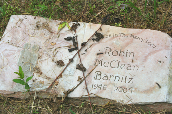
 |
| Lone Tombstone in the Woods |
Though we hadn’t discussed it beforehand, I know we both expected ancient tombstones covered in weeds, with a forest grown up around them. As I climbed over the barbed wire, I saw a clearing about a city block in size, trees on all sides, punctuated with small groupings of tombstones. Tombstones which looked rather … modern. We sat down and broke out the beer and joked about our travails, and the possibility that none of these graves looked older than a decade. Strangely juxtaposed with these gravemarkers was a century-old hand water pump in a corner of the cemetery. As we walked around the headstones we were rather shocked to find that their dates only ranged from about 2006 back to maybe 1970! Amidst the twenty-five or so headstones, there were a couple family plots, but this didn’t seem like a public cemetery. Most notably, I suppose, was the family of Philadelphia Orchestra composer
Richard Yardumian. Very curious.
By the age of the water pump, Frank (who works at a cemetery), thought that maybe this was an old cemetery that had fallen into disrepair and in the late-1960s someone decided to put it to use once again. So we’re both wondering if some astute local historian knows the story and would post some explanatory comments at the end of this blog. All I can offer is that there are small groupings of Armenian family names.
I noticed what appeared to be wooden guardrails uphill at the back of the cemetery, which I took to be a road. Thinking we’d hitchhike back to the car, we climbed a set of stone steps up to the road, which turned out to be not a road at all, but a driveway. Curiouser and curiouser. Seemed to be an estate of some sort. Strange-looking building with many uniformly sized windows along the side facing us, woods all around. Not a soul to be seen, which was good, as we were on their front lawn. We walked up the driveway toward the house, thinking it led
past the house and out to a road. Nope. Just went up to a sort of parking area. I suggested it might be the clubhouse of the human-game hunting club. We headed off in the opposite direction, down the driveway into the woods away from the house. The road meandered through a field and signs that said, 'Private Drive.' Yeah, we knew that – we’re just trying to get the hell out of here.
 |
| Cemetery access road, leading to Creek Road |
Finally, we came to a main road, and saw one of the gates leading into the Nature Preserve. About fifty feet from the driveway was a chained gravel road, leading to the cemetery we just left. Meaning that we could’ve driven right to this gate (had we known where it was), parked the car, walked down the chained road for four minutes and come to the cemetery!
As we approached the gate, a young guy walking a dog came down the road. We asked him if he knew the way back to Pennypack Road and he said just follow the trail on the other side of the creek. The return trip only took an hour or so, as we were on an established trail and back on the grid. Strange how this Creek Road Trail sort of meandered through the backyards of farmhouses, estates, and a big country retreat-looking place called something like Lords of the New Church (not to be confused with the punk supergroup, I suppose). On returning to the car, we were both exhausted and my feet ached. We finished off the remaining cold ones and headed home.
After all that, it turns out that we hadn't found the cemetery we were looking for! I saw Kim and Brad Thompson a week later at an art event and Kim reminded me that the graves in the cemetery
they had found were sunken, with old stones covered with graffiti. I had forgotten that part. So SOMEWHERE between where the tracks began and the boulders covered them, is an old abandoned cemetery nestled in the woods. Sounds like another trip, but it will have to be in the winter, when the trees are bare, the poison ivy is dead, and the beavers are safely under the ice-covered creek.
References and Further Reading:
Pennypack Ecological Restoration Trust
Rabid Beavers Bite Folks in NE Philly
Kim Thompson's
Dark Mind Design


 The whole thing seems kind of stupid if you have no concept of how big beavers get. I for one, was shocked some years ago when I came across this stuffed beaver in a Baltimore thrift shop. The thing was huge, maybe four feet long including the tail! Throughout the day, Frank and I saw deer, snakes, and chipmunks, but met with no beavers (or bears, for that matter, as did the unfortunate hiker in Yellowstone Park last week).

 We were at least a half mile down the tracks when we came to an amazing stone throughcut hill, where the tracks were totally blocked by boulders that had come loose off the excavated rock walls. I offered to Frank that we can turn back anytime he felt like it, but he said, “No, we’ve come this far…” Truthfully, this Bataan Death March was wearing me out and I was beginning to think we took the tracks in the wrong direction. I was exhausted, and dying for one of the chilled beers I offered to carry in Frank’s ungodly heavy cooler, but hey, there’s a time and place to man up, so we made our way over and around the ten-foot high boulders and continued on up the tracks. It was in the nineties and sunny, but at least we were shaded by the majestic old forest for most of our hike.