In the summer of 2024, I was researching forgotten cemeteries for my book, “Abandoned Cemeteries of Philadelphia and its Environs” (expected publication in late 2025, on Fonthill). South Jersey, being in the general area of Philly, was on my radar. I happened to be in Cape May, so why not check out the local cemeteries?
On my drive back north to Philly on Route 9, I noticed some small burial grounds pop up on my phone map. They were right along the highway. I stopped at two of them, plots of land about twenty feet wide, and fifteen feet deep, with maybe as many as ten old headstones standing at attention. The grounds were well taken care of.
 |
| Robert Morris in Holmes Family Cemetery |
One of the topics I cover in my book is the disappearance of such small family burial grounds. Large farms and estates dwindled in size as parcels of land were sold off throughout the 1800s and early 1900s. These family burial grounds either disappeared, were built over, or the graves were moved. Some still exist, providing us with interesting slices of history.
 |
| Holmes Family Cemetery along Route 9, Cape May Court House, NJ |
A cemetery I stopped at on Route 9 in Cape May Court House (that’s the name of the actual town) was a place that my cellphone map app called the Holmes Family Cemetery. Most of the gravestones had a death date in the early 1800s. Someone had placed small American flags on the veterans’ stones, men who had fought in the Revolutionary War. But wait, there was no Battle of Cape May, right? According to the book, Cape May County Story (Avalon Publishing, 1975) by Boyer and Cunningham:
“New Jersey became the foremost state in resisting British tyranny in January of 1775 when the Assembly voted to present grievances to the King. Jonathan Hand and Eli Elrdidge represented Cape May County at that meeting. No colony was more deeply involved in the Revolution than New Jersey. It was a natural passageway between New York and Philadelphia and was always in a condition of siege. Benjamin Franklin likened it to a barrel, open at both ends. It had been called the “Corridor State” and the “Cockpit of the Revolution” by some, and others referred to this state as the “Pathway to Freedom.”

The Holmes Family Cemetery was distinctive in that every headstone had daddy-long-legs spiders on them! Odd. What was even odder was all the other types of spiders dangling from the pine trees on web strands above my head.
 |
About a mile up the road was a rather peculiar small cemetery in that it appeared to be in someone’s front yard. Curious, I parked across the busy street and walked up to the house, which had a pickup truck parked in the driveway. I knocked on the door. A man about 45 years old appeared. I told him I was researching a book on abandoned cemeteries and asked if he knew the story behind the gravestones in his front yard. My cellphone app called this the Hand Family Burial Ground. Perhaps the Jonathan Hand (1728 – 1789) mentioned in the passage above was a member of this family, and may be resting below one of the nameless, worn stones in this plot.
The homeowner asked me to wait while he put his shoes on. He came outside carrying a paperback book. He told me that when he bought the house about twenty years ago, it was explained to him that he did not own that small portion of land in his front yard. It was owned by the state of New Jersey. When Route 9, a state-owned highway, was built, all the small burial grounds along it were purchased by the state. The state maintains them.
 |
| Roadside view of Craig's property, Hand Family Cemetery in foreground |
 |
| Craig's front yard looking toward Route 9, with Hand Family Cemetery near road |

 |
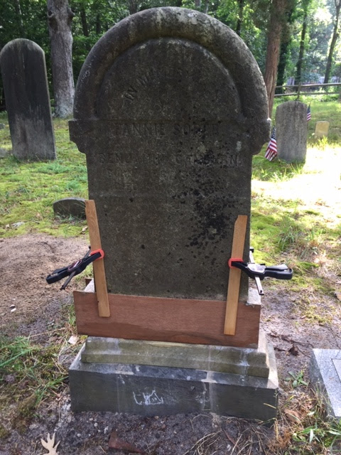
| Sarah Somers (1770 - 1796) |

Sarah Hand (1741 – 1826)
The two small cemeteries I stopped at had been private family burial grounds at the edges of farms. As the farms were diced up and sold as small packets of land for development as residential properties, the burial grounds were kept intact. There is another small cemetery on the grounds of the Cape May Zoo, but I could not find that one. They may all have been forgotten by the public, as they are hidden in plain sight, but they have, thankfully, been saved from oblivion by the state of New Jersey. They may not be as eye-catching as a giant fiberglass cow, but they will outlast most of Jersey's other roadside attractions.